

Data Sets
OAD products are delivered with all the data sets required to facilitate sonar performance predictions on a Global basis. Some of these data sets can be augmented with the users’ own data for specific situations. The embedded data is obtained from established and reputable third party organisations and then processed and enhanced by OAD for use by WADER and HARCAM.
Data Sets
OAD products are delivered with all the required data sets to facilitate sonar performance predictions on a Global basis. Some of these data sets can be augmented with the users’ own data for specific situations. The embedded data is obtained from established and reputable 3rd party organisations and then processed and enhanced by OAD for use by WADER and HARCAM.

Meteorological Data
Tactical Planning Charts
Wave Height
Gale Probability
Surface Wind Speed
Surface Air Pressure
Surface Air Temperature
Surface Dew Point
Surface Air Temperature minus Surface Dew Point
Surface Sea Temperature minus Surface Dew Point
simple charts. These charts can be used to prepare briefing notes and also provide sea state data for the propagation loss models.
The source data was processed by OAD to produce a set of
1 degree
1 month
Notes:
Temporal resolution:
Spatial resolution:
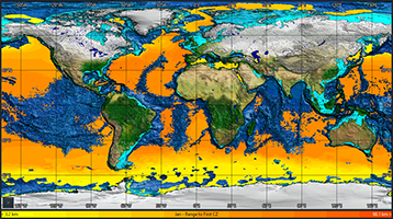
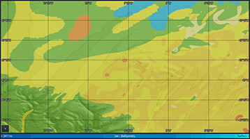
We are proud of the Range to First Convergence Zone (CZ) charts which show where CZ conditions can be found and what the expected ranges will be. The charts are constructed using water column and bathymetry data together with the HODGSON propagation loss model (chart example: January).
- Secondary Layer Base
- Shallowest Channel
- Depth Excess
- Range to First Convergence Zone
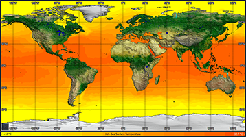
- Sea Surface Temperature
- Sea Surface Salinity
- Sonic Layer Depth
The US Navy Marine Climatic Atlas of the World (USMCAW)
Source:
The charts are:
0.25 degree
1 month
Notes:
Notes:
Temporal resolution:
Temporal resolution:
Spatial resolution:
Spatial resolution:
OAD (from WOA and GEBCO)
Source:
Source:
extend to the seabed and all grid squares are supplied with a profile.
This climatological data is supported by Expendable Bathythermograph (XBT) from the WOA. The WOA provides approximately 500,000 measured XBT taken at random times and with random distribution.
Since WADER V9.1 users can upload their own high-resolution water column data in NetCDF format where available and appropriate.
OAD spatially enhances the data to ensure that all profiles
1 month
0.25 degree
World Ocean Atlas
Water Column Data
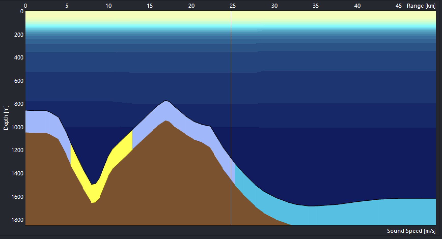
same dataset has been transposed using recognised algorithms by OAD to provide data suitable for both mid and low frequencies. The data is available to view graphically (as chart overlays and as seabed reflection loss curves) and is used by the program for calculations.
HFEVA is used in its original format for higher frequencies. The
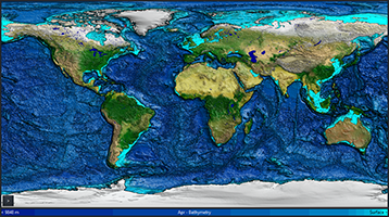
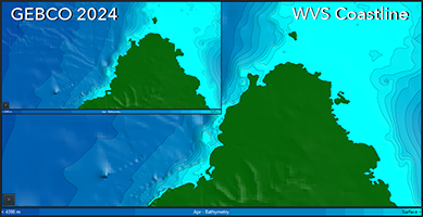
Water Depth & Land Elevation
World Vector Shoreline Data
is suitable for the open ocean but provides limited coastline definition when ‘zoomed in’ (especially around island areas). WVS data provides an effective way of drawing high definition coastlines.
Standard WADER charts are drawn using bathymetry data. This
World Vector Shoreline, NGDC, Boulder, Colorado (WVS)
V8.4 and above allows users to upload their own high-resolution bathymetry data in ESRI Raster Format (ASCII) where available and appropriate. Data resolution can be as high as 0.5m.
OAD endeavour to supply the highest quality data available.
1:100000
N/A
Source:
Temporal resolution:
Spatial resolution:
Source:
GEBCO 2024*
Spatial resolution:
Temporal resolution:
Notes:
Notes:
Notes:
N/A
15 arc seconds
6 arcsec (regional), 5 arcmin (most other areas)
N/A
Temporal resolution:
Spatial resolution:
HFEVA Stennis Space Centre 2024*
Source:
Sediment Data
only.
only.
Contact OAD for further details
Contact OAD for further details
* Dataset used for
* Dataset used for
WADER
WADER
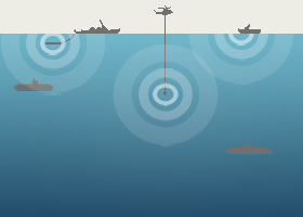
Sonar Data
Therefore OAD have created a set of Sonar Parameters for Unclassified Training (SPUTS) which are designed to emulate the behaviour of real sonars for training and planning purposes. For operational use, WADER will require the actual parameters of any relevant sonars to be uploaded by the user.
The majority of military sonar parameters are classified.
OAD
Source:
Notes:
Meteorological
The US Navy Marine Climatic Atlas of the World (USMCAW)
1 degree
1 month
Data:
Source:
Spatial Resolution:
Temporal Resolution:
1 month
Tactical Planning Charts
OAD (from WOA and GEBCO)
0.25 degree
1 month
Data:
Source:
Spatial Resolution:
Temporal Resolution:
1 month
Water Column
World Ocean Atlas 2018
0.25 degree
1 month
Data:
Source:
Spatial Resolution:
Temporal Resolution:
Since WADER V9.1 users can upload their own high-resolution water column data in NetCDF format.
Water Depth & Land Elevation
GEBCO 2024*
Contact OAD for further details
* Dataset used for
WADER
15 arc seconds
N/A
Data:
Source:
Spatial Resolution:
Temporal Resolution:
1 month
World Vector Shoreline
World Vector Shoreline, NGDC, Colorado (WVS)
1:10000
N/A
Data:
Source:
Spatial Resolution:
Temporal Resolution:
Sediment
HFEVA 2024 Stennis Space Centre*
6 arcsec (regional), 5 arcmin (most other areas)
N/A
Data:
Source:
Spatial Resolution:
Temporal Resolution:
only.
Contact OAD for further details
* Dataset used for
WADER
Sonar Parameters for Unclassified Training
OAD
N/A
N/A
Data:
Source:
Spatial Resolution:
Temporal Resolution:
OAD